Environmental Assessment of Crystal Lake (2009)
A major goal for the CLC is to provide an environmental assessment of the Lake. This includes hiring experts to determine the effects of lawn care practices within the Lake’s watershed, the effects of storm water drainage into the lake, and the impact of activities associated with the use of the Lake. It will undertake to distribute the results of the assessment widely and to update this information periodically.
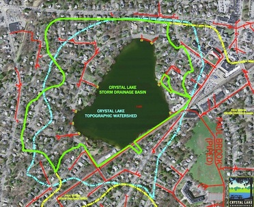
Watershed Map
The Crystal Lake Watershed is the area that effectively slopes toward the Lake. Clearly, those homes and streets within the watershed area have a direct effect on the Lake’s water quality. However, it may surprise many people to find that even though they do not live directly in the topographic watershed, due to the configuration of street drainage systems what they do on their street and in their yards also has an effect on the Lake’s water quality. Take a look at the map. The Blue line is the topographic watershed; the Green line is the extended watershed created by the street drainage systems (represented by the Red lines).
Watershed Analysis
Of equal importance to understanding the quality of the lake, is developing a comprehensive understanding of the watershed that contributes to Crystal Lake. As such, we will engage in the following:
Watershed monitoring
This activity would involve an extensive on the ground survey of the watershed to assess stormwater systems, fertilizer applications, pesticide uses, and any other land uses within the Crystal Lake Watershed that may potentially affect the water quality of Crystal Lake.
Land Use Analysis
Beals Associates has developed a detailed watershed map of the entire Crystal Lake Watershed (as seen below) utilizing USGS topographic maps, Massachusetts GIS information, City of Newton plans and any other available information relevant to the Crystal Lake Watershed. This map identifies the watershed boundary both in terms of surface run-off as well as subsurface conditions that may include aquifers and stormwater drainage systems. THe land use analysis base map of the Crystal Lake Watershed identifies land uses, utilities, drainage, soils, impervious surfaces, stormwater systems, and any other land uses within the watershed that may directly or indirectly affect the water quality of Crystal Lake.
Watershed Management
Based on the analysis and monitoring of the watershed described above, Crystal Lake Conservancy will develop a watershed management plan that will address such items as an improvement of land use practices such as fertilizer as well as stormwater management as necessary to improve recharge, reduce suspended solids, and reduce any contaminates that may be flowing from non-point source basis into Crystal Lake.
Water Quality Monitoring Program
The Crystal Lake Conservancy has developed a water quality monitoring program. This program has been developed from guidance from Beals Associates and recommended practices and protocols developed by the US Environmental Protection Agency and applicable to New England Lakes. The monitoring program defines the parameters to be studied, the frequency of sampling, and the personnel required to perform the sampling.
Water Quality Analysis
Beals Associates will work with the Crystal Lake Conservancy to develop an analysis procedure for collecting, analyzing, interpreting, and preparing conclusions regarding the water quality of Crystal Lake as a consequence of the empirical data obtained from the monitoring program. The purpose of the water quality analysis is to assess the current condition of the lake and to continuously review the monitoring program data to assess any trends or changes in the lake water quality.
Testing Sites for Monitoring and Analysis

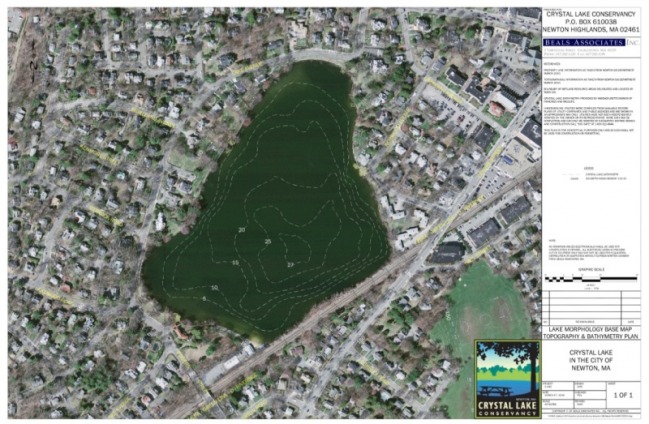
Lake Morphology Base Map
From existing information sources including US Geological Survey, Topographical Quadrangles, and the Massachusetts GIS system, Beals Associates has developed a base map showing Crystal Lake as well as the surrounding watershed. In addition to surface topography, Beals Associates has developed a bathometric survey of the lake bottom (see below) to assess the morphological characteristics of the lake. The bathometric survey was performed by obtaining soundings from either a boat or from the surface of the lake once it is frozen. The location of the soundings will be plotted using GPS technology. The soundings and locations will be used to prepare a plan showing the lake depth and associate contours.
Lake Management Recommendations
Once a thorough data base of the characteristics of Crystal Lake both quantitatively and qualitatively have been developed, Crystal Lake Conservancy will develop lake management recommendations and a strategy for implementing those recommendations.
How To Volunteer
To participate in the monitoring program please contact Jean Artin at [email protected]. Volunteers must wear life jackets and rowboat provided and will be trained in the simple testing equipment for temperature, water clarity, etc.. utilizing a GPS device for exact recurring testing sites designated around Crystal Lake.
